Share This Story, Choose Your Platform!
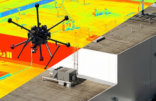
Facility thermal drone inspections are more than just colorful video footage or photos. When drone services are provided by property professionals, the camera captures data most relevant to the specific needs of property managers. The more familiar a drone operator is with a property and its trouble spots, the better the resulting analysis.
While the quality of non-thermal drones is dependent on camera lens quality, resolution, and image storage, thermal drones raise the stakes. The quality of thermal cameras can vary considerably in price depending on sensitivity, targeted accuracy, and range of datapoints collected.
Color changes can provide good basic information about the general location of trouble spots, which may be adequate for some situations. Upper end units have radiometric thermal cameras which can provide the temperatures of various pinpoint locations within an image.
However, capturing the data is only part of the process. Another critical aspect of thermal drones is the software used to capture, collect, and process large volumes of critical information in real time and during post-flight analysis. The ability to process all of the datapoints for meaningful analysis separates the professional thermal drone operations from the hobbyists posing as surveyors. Inspections from equipment that costs nearly twenty thousand dollars produces far different results than drone gear that costs a fraction of that.
Roof inspections are one of the most obvious uses for thermal drones. These areas typically serve as hubs for utilities. Heat sensing detection can reveal problems with HVAC equipment, poorly insulated areas, structural issues, roof penetrations, and even water damage when evaluated by an experienced drone pilot.


Utility control panels can be assessed with thermal imaging. Alleys, parking lots, fenced areas, and behind buildings are common utility equipment areas easily accessed by a drone. Nearby utility poles, transformers, and powerlines are also ideal inspection points for detecting wasteful energy loss. Mitigate the high cost of commercial electricity with a thermal drone energy audit.
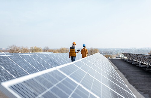
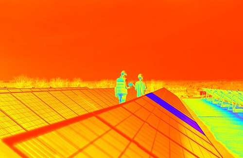
Solar panels are another area in which inefficiencies and problems can be revealed via heat imaging drones. Variations in panel activity is easily identified by changes in color. You can also thermally image properties to identify the best location to place solar panels.


Preventative maintenance saves facility managers time and money by avoiding larger problems, scheduling repairs to minimize downtime, and enabling strategic planning with Information collected through drone imaging. Even events that may go unnoticed, such as normal wear and tear, loose connections, and nearly imperceptible defects can be revealed in a timely manner with thermal imaging.
It is not just buildings that benefit from these types of inspections. Large properties, parking lots, and landscaped areas can reveal anomalies and problem areas. Pooling water, insect & animal activity, and hots spots can be revealed. Troubleshooting lighted signs and equipment in high places can also be achieved with thermal imaging.
Recording property conditions can be useful for supporting future insurance claims. Before and after documentation can assist in investigating and validating property problems. Drone imaging can be recorded and saved on the cloud for anytime, anywhere access.
Full aerial views can help with strategic planning while closeup images can reveal root causes. Working with your current property services company is ideal if they offer drone services. These professionals are in the best position to understand your property needs and problem areas.
The tools exist today for asset managers to be proactive in their approach. Maintenance costs can be reduced through thorough inspections. Identifying problems early is an important key to help save time and money and prevent minor issues from becoming critical. Consider thermal drone imaging to help get critical, analytical information for managing your property effectively.
Resources:
High Resolution Thermal Imaging for Drones: Changing the Game on Building Inspections
https://dronelife.com/2018/07/25/high-resolution-thermal-imaging-for-drones-changing-the-game-on-building-inspections
Drone Training, News, and Resources
https://uavcoach.com
Thermographic Inspections – U.S. Dept of Energy
https://www.energy.gov/energysaver/thermographic-inspections
Thermal Imaging: How can this technology be useful?
https://a-actionhomeinspection.com/inspection-services/thermal-imaging
